
Rasuwa Flood: Can Technology Give Nepal the Minutes That Save Lives?

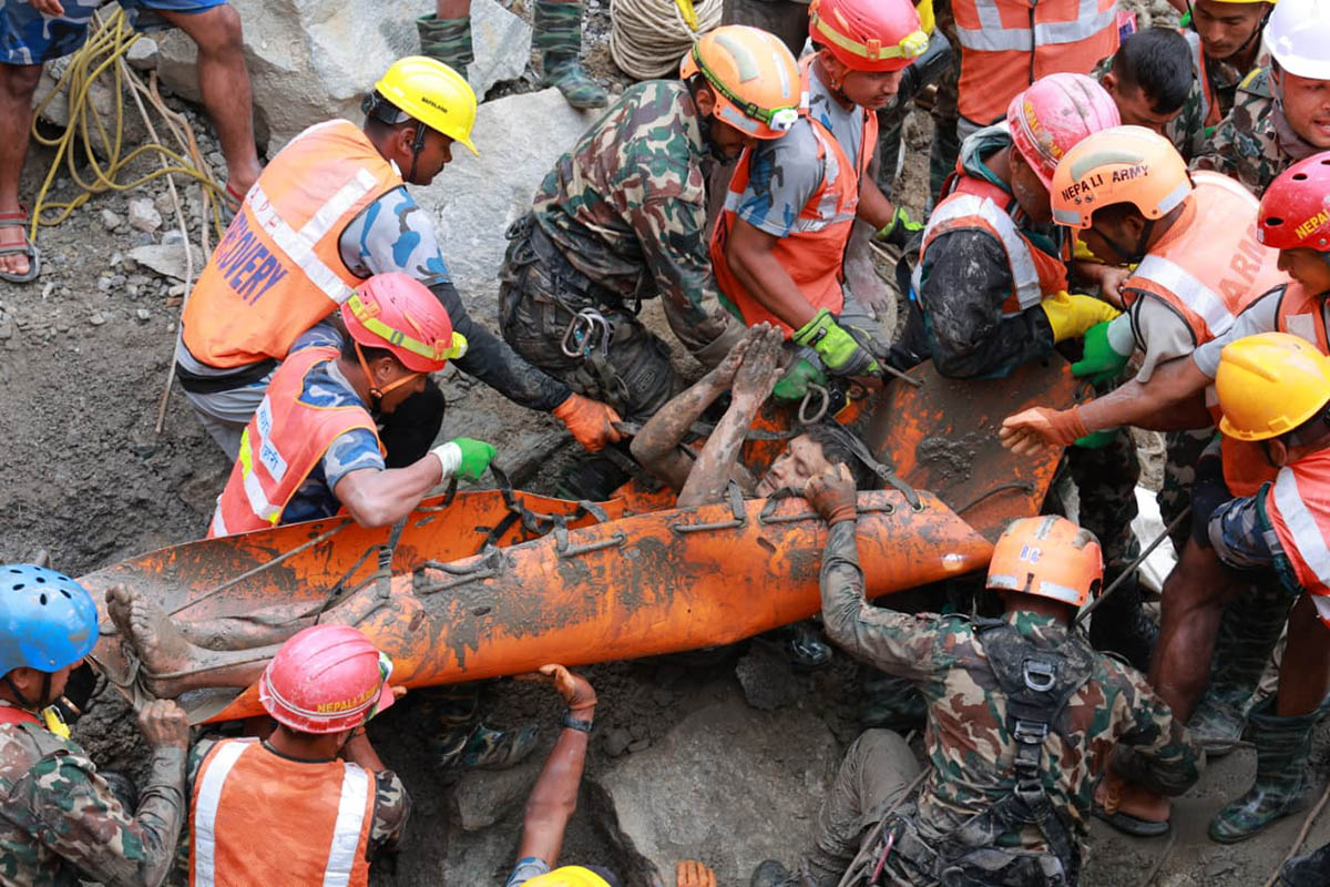
On August 26, Nepal witnessed a devastating reminder that, in the age of artificial intelligence, satellites and instant digital communication, nature can still move faster than information. A catastrophic ice-rock avalanche from the Langtang Lirung massif descended into the Lhende catchment, generating a destructive flood and debris flow through the Bhotekoshi-Trishuli corridor. Settlements, roads, bridges, hydropower infrastructure and communication systems were caught in its path.
Scientists are still refining the exact dynamics of the event, but one fact is already clear: Rasuwa was not only a story about geology, glaciers and rivers. It was also a story about information technology - how quickly data can be collected, interpreted, transmitted and converted into a warning capable of saving lives.
For Nepal, this distinction is crucial. We usually associate IT with software companies, AI, digital payments, e-governance, cloud computing and startups. Yet some of the country’s most important technologies in the coming decades may sit quietly on a mountain, orbit hundreds of kilometres above Earth, analyse seismic signals in a data centre or send an emergency notification to a mobile phone.
Rasuwa forces us to broaden our definition of digital transformation. Technology is not only about making life more convenient. Properly designed, it can become infrastructure that protects life itself.
The technological challenge exposed in Rasuwa can be understood through one word: time.
ICIMOD’s reconstruction says the Department of Hydrology and Meteorology’s Flood Forecasting Division sent SMS alerts to around 679,000 people in Rasuwa, Nuwakot, Dhading and Chitwan at approximately 9:15-9:16 a.m. But the flood had already reached upper border settlements. There was effectively no useful warning for Rasuwagadhi and Timure, while communities farther downstream had more time to react.
Separate reporting based on the Flood Forecasting Division’s reconstruction indicates that a sensor near the Nepal-China border had been transmitting information every 10 minutes. Data arrived normally until 8:40 a.m.; the 8:50 reading did not arrive.
From an IT perspective, that is an extraordinary detail. A missing packet of environmental data can itself become information. The question is whether our systems are intelligent enough to recognise its significance immediately.
Nepal must move from digital monitoring to intelligent monitoring.
Imagine an upstream river sensor suddenly stops transmitting. That could simply mean a battery failure, damaged antenna or network interruption. But suppose, within the same minutes, a seismic station records an unusual signal near a glacier and another downstream sensor detects abnormal changes.
A conventional system may display these observations on different screens operated by different institutions. An intelligent system should correlate them automatically. Instead of waiting for someone to notice that several unusual things are happening simultaneously, software should flag the combination as a potential emergency.
This is where AI can play an important role. Much of today’s public conversation about AI revolves around tools that write text, generate images or answer questions. Disaster management requires a different application: pattern recognition and anomaly detection.
Machine-learning systems can continuously examine environmental data - river levels, rainfall, seismic vibrations, glacier movement, temperature, satellite observations and historical disaster records - and identify patterns that depart sharply from normal conditions. AI does not need to predict the exact second a mountain will collapse to be valuable. Identifying an abnormal combination of signals several minutes earlier could be enough to change outcomes.
Rasuwa also demonstrates why Nepal’s early-warning architecture cannot depend predominantly on river gauges and rainfall data. The August 26 event was associated with a high-altitude slope failure involving bedrock and glacier ice. The hazard began above the conventional river-monitoring network.
Nepal therefore needs to extend its digital eyes upward. High-risk Himalayan areas could increasingly be monitored using seismic instruments, automatic weather stations, GPS deformation sensors, ground-based radar, cameras, acoustic sensors and other Internet of Things devices. The objective should be to detect a dangerous process as close to its source as technically possible.
Then there are satellites - the eyes in the sky that became extraordinarily important after the disaster.
Earth-observation systems helped trace the event, analyse its source and assess damage. The European Union’s Copernicus Emergency Management Service activated its Rapid Mapping service. Its analysis of Syabrubesi and Timure used very-high-resolution imagery and delineated 237 hectares affected by mass movement. Hundreds of buildings were assessed, while hydropower facilities, bridges and approximately 9.5 kilometres of primary road, including part of the Pasang Lhamu Highway, were identified as destroyed.
Technology allowed experts to examine devastated terrain from space when physical access was extremely difficult.
Satellite images are no longer simply photographs of Earth. They are datasets. Computers can compare images captured before and after a disaster to identify where rivers widened, roads disappeared, buildings were damaged or debris accumulated. Synthetic Aperture Radar is particularly valuable because it can observe Earth’s surface through clouds and at night - critical in Nepal, where major disasters frequently coincide with monsoon cloud cover.
But satellite technology should not be limited to post-disaster mapping. A national Himalayan risk platform could routinely analyse imagery of glaciers, glacial lakes, unstable slopes and river corridors. Computer-vision algorithms could flag changes in lake area, glacier retreat, surface displacement or slope deformation for expert review. Machines would not replace scientists; they would dramatically expand the scale and speed of observation.
Rasuwa also highlights a fundamental principle of computer science: redundancy.
A resilient digital system should never depend entirely on one device, communication network or data centre. Sensors can be destroyed by the disasters they monitor. Communications and electricity can fail. Nepal’s monitoring infrastructure should therefore be built like mission-critical IT infrastructure, with backups. If one river gauge fails, neighbouring sensors should continue supplying information. If mobile internet disappears, radio or satellite communication should remain available. If a central server goes offline, another should take over.
The principle is familiar to every competent IT engineer: never create a single point of failure for a critical service.
Communication becomes equally important once danger is detected. The approximately 679,000 SMS alerts issued after the Rasuwa flood demonstrate the reach of Nepal’s telecommunications infrastructure. But emergency communication can become smarter.
Nepal should explore greater use of cell broadcast, allowing authorities to push geographically targeted emergency notifications to compatible phones connected to mobile towers. A tourist entering a danger zone, a driver passing through and a resident beside the river could potentially receive the same location-specific warning.
The warnings themselves should also improve. “Flood danger” is far less useful than a message identifying the affected river, communities that should evacuate, safe locations and the estimated time available.
Geographic Information Systems can help make this possible. By combining real-time hazard information with data on settlements, roads, rivers, hospitals, schools and infrastructure, software could automatically identify communities at risk and deliver location-specific instructions.
“Nepal’s monitoring infrastructure should be built like mission-critical IT infrastructure, with backups. If one river gauge fails, neighbouring sensors should continue supplying information. If mobile internet disappears, radio or satellite communication should remain available. If a central server goes offline, another should take over.”
This leads to one of the most promising technological possibilities for Nepal: digital twins of vulnerable river corridors.
Imagine a continuously updated digital replica of the Bhotekoshi-Trishuli corridor containing its mountains, glaciers, rivers, roads, bridges, settlements, hydropower plants, telecommunications towers and evacuation routes. Live information from sensors, satellites, weather stations and seismic networks would flow into the model.
If a major slope failure were detected, computers could simulate downstream paths, estimate arrival windows and identify exposed communities and infrastructure. Emergency officials would see not simply a spreadsheet of water levels but a dynamic map of the hazard moving downstream—showing which settlement may be affected first, which bridge is at risk, which hydropower facility should initiate emergency procedures and where communities should evacuate.
Drones should form another layer of this ecosystem. When roads and bridges disappear, drones can become the fastest eyes available to emergency teams. Equipped with cameras, thermal sensors and mapping equipment, they can survey inaccessible valleys, search for stranded people, inspect infrastructure and create three-dimensional models of damaged areas. Larger drones could potentially deliver medicine, radios, batteries and lightweight emergency supplies to isolated communities.
Technology could also transform rescue coordination. During major disasters, information arrives from police, the army, local governments, hospitals, volunteers, social media and families. Without a common digital platform, duplicate reports and conflicting information can overwhelm decision-makers.
Nepal needs interoperable disaster-management systems through which agencies can share verified incidents, missing-person records, blocked roads, rescue requests, shelter capacity and resource availability in near real time. A common operational dashboard would provide authorities with a shared picture rather than forcing each institution to construct its own.
The same philosophy should shape infrastructure planning. Before approving a highway, bridge, hydropower project or settlement expansion in a high-risk Himalayan corridor, planners should be able to overlay decades of satellite imagery, historical floods, landslide inventories, glacier data, elevation models and climate projections. Technology should help Nepal ask not only, “Can we build here?” but also, “What could happen here 20 years from now?”
Rasuwa further demonstrates that Nepal’s disaster-data architecture cannot stop at the national border. Himalayan rivers, glaciers and weather systems do not carry passports. Stronger real-time cross-border exchange of hydrological, meteorological, seismic and cryosphere information could give downstream communities additional warning time. A sensor across an international border may be more useful to a Nepali settlement than one hundreds of kilometres downstream inside Nepal.
This digital transformation also introduces another priority: cybersecurity. When warnings depend on connected sensors, cloud platforms, APIs, telecommunications networks and automated systems, cybersecurity becomes public safety. Nepal’s future disaster infrastructure will require encrypted communications, authenticated alerts, secure data centres, redundant servers, strict access controls and reliable backups.
But Nepal must avoid believing that purchasing sophisticated equipment automatically creates technological preparedness. A million-dollar sensor is useless if nobody monitors its data. An AI model is useless if agencies cannot interpret its alerts. A satellite map is useless if it reaches decision-makers after evacuation time has passed. And an emergency notification is useless if communities do not understand what it means.
The real challenge is systems integration—connecting technology, institutions and communities into one functioning chain.
That chain has five steps: detect, analyse, decide, communicate and act. Sensors detect an abnormal event. Software and experts analyse it. Authorities decide whether a warning threshold has been reached. Telecommunications systems communicate instructions. Communities act.
If any link takes too long, the value of every sophisticated technology before it diminishes.
“Rasuwa should become a case study not only for hydrologists, geologists and disaster officials, but for Nepal’s technology community. Software engineers, AI researchers, tele-communications companies, cybersecurity professionals, GIS specialists, drone operators, universities and startups all have a role.”
Rasuwa should therefore become a case study not only for hydrologists, geologists and disaster officials, but for Nepal’s technology community. Software engineers, AI researchers, telecommunications companies, cybersecurity professionals, GIS specialists, drone operators, universities and startups all have a role.
The most important measurement of their technology will not be processing power, model size or the number of sensors installed. It will be minutes gained.
Can technology detect danger five minutes earlier? Can an algorithm analyse a signal two minutes faster? Can automation remove another three minutes from institutional communication? Can targeted alerts deliver instructions almost instantly?
In an ordinary software application, 10 minutes may mean little. In a fast-moving Himalayan flood, 10 minutes can represent an entirely different outcome.
Nepal cannot stop mountains from moving, glaciers from changing or rivers from flooding. Technology cannot eliminate the forces that created the Rasuwa disaster. What it can change is our relationship with time. It can allow us to see farther, detect earlier, analyse faster and communicate more intelligently.
For years, Nepal’s technology conversation has focused on building a digital economy. We should now expand that ambition toward building a digitally resilient country.
Somewhere high above a Himalayan settlement, the next dangerous change may begin as a movement invisible to the human eye. The challenge is to ensure that a satellite can see it, a sensor can feel it, an algorithm can recognise it, a network can communicate it and a community can act before the mountain reaches them.
In the Himalayas of the future, the most valuable technology may ultimately be the one that gives people a few more minutes to live.

-1786444150.jpg)
-1784801453.jpg)
-1782892210.jpg)